39. NAV-SOLE (Ship's position with the sun - meridian)
This program calculates the ship's position using two observations of the sun and a final observation at noon. Our suggestion is to carry out every day the position of the vessel using the observation of the sun at noon, because it is better to check the GPS or satellite.
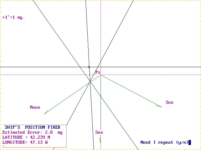
It is possible to calculate also an observation of the moon together
with two observations of the sun. The movements of the sun and the moon
have been calculated till the 2999 year (100 years) and the use of ephemerides
are not more necessary to check; therefore this calculation appears very
quick.
When the calculation has been completed by the computer, it is possible
to obtain the coloured graph and print out it. The program requires the
scale extension of the graph and for example we can write 60 to obtain
a graph 60 miles wide or 120 for 120 miles wide, and so on. At the end,
the program requires if we need the bisecting lines or not in the graph.
You can write "Y" (YES) or "N" (NOT).
If you write "Y" i.e. YES the program ask you as follows:
How many bisecting lines? Write 2
The first bisetting line? Write 1.2 or 2.3
The second bisetting line? Write 1.3
Depending the bisetting line you need; i.e. between line 1 and 3 you
have to write 1.3 and between line 1 and 4 you can write 1.4 and so on.
At the end the program gives the true position of the vessel (Latitude
and Longitude) also a complete calculation effected and also a coloured
graph.
When you have the coloured graph at your monitor you can strike the print
Key(in the up-right your keyboard); after this you have to open MS-PAINT
program or WINWORD7 program.
In the MODIFY menu click on copy and paste. The graph will appear again
and you can print it and change also colours using MS-PAINT program.
|
|
|